
ЫбЫїНсЙћ: 1-15 ЙВВщЕНЁАЙЄбЇ radarЁБЯрЙиМЧТМ173Ьѕ . ВщбЏЪБМф(0.078 Уы)
ЙтЕчаХЯЂДѓНВЬУЕк211ЦкЃКSilicon-Based Mm-Wave Circuit Techniques for Communication and Radar
КСУзВЈаОЦЌ ЙшЛљЙЄве ЭЈаХаОЦЌ
font style='font-size:12px;'>
2023/4/17
КСУзВЈОпгаЗсИЛЕФЦЕТЪзЪдДЃЌвбж№ВНгІгУгкИпЫйЭЈаХКЭИпОЋЖШРзДяЕШСьгђЁЃЕЋгЩгкЙшЛљЙЄвеБОЩэЕФЯожЦЃЌВЩгУЙшЛљЙЄвеЪЕЯжКСУзВЈаОЦЌУцСйОоДѓЕФММЪѕЬєеНЁЃБОБЈИцЬжТлСЫЙшЛљКСУзВЈаОЦЌММЪѕЕФЗЂеЙвдМАЫљУцСйЕФММЪѕЬєеНЃЌНщЩмСЫБОПЮЬтзщдкНтОіПэДјЪеЗЂСДТЗЁЂИпОЋЖШКСУзВЈаХКХдДКЭЯрПиеѓЕШЗНУцЕФЙЄзїЃЌВЂМђвЊНщЩмСЫБОПЮЬтзщПЊЗЂЕФКСУзВЈРзДягыЭЈаХаОЦЌЁЃ
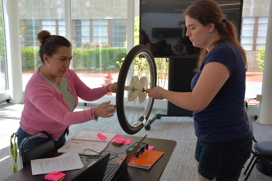
Teachers learn radar basics in LLRISE outreach programЃЈЭМЃЉ
LLRISEЭтеЙМЦЛЎ РзДяЛљДЁжЊЪЖ РзДя
font style='font-size:12px;'>
2023/6/8
For high school teachers Esmeralda Hernandez and Liz Raine, radar is not a topic typically part of their curriculums. Hernandez teaches mathematics at Jubilee Brownsville High School in Brownsville, T...
GEOPHYSICAL PARAMETER RETRIEVAL FOR MICROWAVE C BAND SYNTHETIC APERTURE RADAR (SAR) DATASET USING INTEGRAL EQUATION MODEL
Microwave SAR Geophysical Parameters IEM Modelling
font style='font-size:12px;'>
2019/2/28
The microwave remote sensing is highly useful, as it provides synoptic observation of the EarthЁЏs surface or planetary bodies, regardless of day or night and the atmospheric conditions, propagation th...
RADAR CROSS SECTION CHARACTERIZATION OF CORNER REFLECTORS IN DIFFERENT FREQUENCY BANDS AND POLARIZATIONS
Corner Reflector Radar Cross Section Trihedral Dihedral Compact Antenna Test Range Facility Calibration
font style='font-size:12px;'>
2019/2/28
Corner Reflectors (CR) are standard passive radar targets which offer one of the best solutions for SAR calibration. Radar Cross Section (RCS) of corner reflectors plays a vital role for estimation of...
ASSESSING THE CONDITION OF BURIED PIPE USING GROUND PENETRATING RADAR (GPR)
Ground Penetrating Radar (GPR) Pipe deterioration Buried utilities
font style='font-size:12px;'>
2018/11/8
The invention of Ground Penetrating Radar (GPR) technology has facilitated the possibility of detecting buried utilities and has been used primarily in civil engineering for detecting structural defec...
COMBINED VISUAL EXPLORATION OF 2D GROUND RADAR AND 3D POINT CLOUD DATA FOR ROAD ENVIRONMENTS
Ground Penetrating Radar 3D Point Cloud Infrastructure Maintenance
font style='font-size:12px;'>
2018/11/9
Ground-penetrating 2D radar scans are captured in road environments for examination of pavement condition and below-ground variations such as lowerings and developing pot-holes. 3D point clouds captur...
INFRARED ROTATION PLANE RADAR CHANGE DETECTION
Infrared Rotation Plane Radar Change Detection Depth Information Mixed Gaussian Background Modeling
font style='font-size:12px;'>
2018/5/15
The existing change detection method mainly stays on the pixel-level, which is very susceptible to light, shadow, etc. And the complex calculation and analysis for each pixel reduce the detection effi...
FLOOD EXTENT MAPPING USING DUAL-POLARIMETRIC SENTINEL-1 SYNTHETIC APERTURE RADAR IMAGERY
Flood Polarimetry SAR Radar Harvey Sentinel-1
font style='font-size:12px;'>
2018/5/14
Rapid generation of synthetic aperture radar (SAR) based flood extent maps provide valuable data in disaster response efforts thanks to the cloud penetrating ability of microwaves. We present a method...
MEASUREMENT OF SEAWARD GROUND DISPLACEMENTS ON COASTAL LANDFILL AREA USING RADAR INTERFEROMETRY
SAR SAR Interferometry Multiple-Aperture SAR Interferometry Coastal landfill Three-dimensional measurements
font style='font-size:12px;'>
2018/5/11
In order to understand the mechanism of subsidence and help reducing damage, researchers has been observed the line-of-sight subsidence on the Noksan industrial complex using SAR Interferometry(InSAR)...
EARTHQUAKE BUILDING DAMAGE MAPPING BASED ON FEATURE ANALYZING METHOD FROM SYNTHETIC APERTURE RADAR DATA
Building Damage Assessment Earthquake Emergency Feature Analysing SAR
font style='font-size:12px;'>
2018/5/11
Playing an important role in gathering information of social infrastructure damage, Synthetic Aperture Radar (SAR) remote sensing is a useful tool for monitoring earthquake disasters. With the wide ap...
SEA ICE THICKNESS MEASUREMENT BY GROUND PENETRATING RADAR FOR GROUND TRUTH OF MICROWAVE REMOTE SENSING DATA
Sea ice thickness measurement, Microwave remote sensing Ground truth Ground Penetrating Radar Brackish lake Finite-Difference Time-Domain method Dielectric constant
font style='font-size:12px;'>
2018/5/15
Observation of sea ice thickness is one of key issues to understand regional effect of global warming. One of approaches to monitor sea ice in large area is microwave remote sensing data analysis. How...
MONITORING OF HORIZONTAL MOVEMENTS OF HIGH-RISE BUILDINGS AND TOWER TRANSMITTERS BY MEANS OF GROUND-BASED INTERFEROMETRIC RADAR
Ground-based radar interferometry Horizontal movements Deformations High-rise buildings Tower transmitters
font style='font-size:12px;'>
2018/4/18
The paper describes possibilities of the relatively new technics ЈC ground based radar interferometry for precise determining of deformation of structures. Special focus on the horizontal movements of ...
MONITORING OF HORIZONTAL MOVEMENTS OF HIGH-RISE BUILDINGS AND TOWER TRANSMITTERS BY MEANS OF GROUND-BASED INTERFEROMETRIC RADAR
Ground-based radar interferometry Horizontal movements Deformations High-rise buildings Tower transmitters
font style='font-size:12px;'>
2018/5/8
The paper describes possibilities of the relatively new technics ЈC ground based radar interferometry for precise determining of deformation of structures. Special focus on the horizontal movements of ...
жаЙњЕижЪДѓбЇПЦбЇММЪѕЗЂеЙдКдЌдУЗц(ВЉЪПЩњЃЉЃЌжьХрУёЕиПебЇдК Geophysical Research LettersЃЌ16 July 2017. The 3-D Geological Model around the Chang'E-3 Landing Site based on lunar penetrating radar Channel 1 data
Ш§ЮЌЃЛЬНдТЃЛРзДяЃЛПЦбЇЃЛвЧЦї
font style='font-size:12px;'>
2021/10/21
2017Фъ7дТЃЌжаЙњЕижЪДѓбЇЕиПебЇдКВЉЪПбаОПЩњдЌдУЗцгыЦфЕМЪІжьХрУёНЬЪкЕШШЫгкЕиЧђЮяРэбЇСьгђЙњМЪжјУћЦкПЏЁЖGeophysical Research LettersЁЗЩЯЗЂБэСЫТлЮФЁАThe 3-D Geological Model around the Chang'E-3 Landing Site based on lunar penetrating radar Channel 1 dataЁБЁЃИУЮФеТЭЈ...
Researchers develop radar simulator to characterize scattering of debris in tornadoes
Researchers radar simulator scattering debris tornadoes
font style='font-size:12px;'>
2017/7/19
Researchers have developed the first numerical polarimetric radar simulator to study and characterize the scattering of debris particles in tornadoes. (See video)
The results of their study are publi...
жаЙњбаОПЩњНЬг§ХХааАё-Ьѕ
- е§дкМгди...
жаЙњбЇЪѕЦкПЏХХааАё-Ьѕ
- е§дкМгди...
ЪРНчДѓбЇПЦбаЛњЙЙХХааАё-Ьѕ
- е§дкМгди...
жаЙњДѓбЇХХааАё-Ьѕ
- е§дкМгди...
ШЫЁЁЮя-ЦЊ
- е§дкМгди...
ПЮЁЁМў-ЦЊ
- е§дкМгди...
ЪгЬ§зЪСЯ-ЦЊ
- е§дкМгди...
баеазЪСЯ -ЦЊ
- е§дкМгди...
жЊЪЖвЊЮХ-ЦЊ
- е§дкМгди...
ЙњМЪЖЏЬЌ-ЦЊ
- е§дкМгди...
ЛсвщжааФ-ЦЊ
- е§дкМгди...
бЇЪѕжИФЯ-ЦЊ
- е§дкМгди...
бЇЪѕеОЕу-ЦЊ
- е§дкМгди...