
搜索结果: 1-15 共查到“理学 Remote sensing”相关记录205条 . 查询时间(0.243 秒)

中国科学院东北地理所在Remote Sensing of Environment上发表全新水稻遥感制图方法(图)
遥感 卫星 气候
font style='font-size:12px;'>
2024/9/13
水稻作为全球重要的粮食作物之一,在保障粮食安全和促进农村经济发展中发挥着关键作用。因此,准确及时的水稻制图对相关政策制定至关重要,以应对人为、环境和气候变化带来的挑战。与传统田间调查相比,卫星遥感在水稻制图和监测方面具有大面积覆盖、及时监测和低成本等独特优势,已成为水稻监测制图的主要技术手段。目前,水稻遥感制图方法主要有三种,基于分类器、基于物候和基于指数方法。基于分类器的方法是最常用的,但这些数...

新疆生地所在Remote Sensing of Environment发表古尔班通古特沙漠不同类型生物土壤结皮高精度空间分布图(图)
土壤 生态系统 气候
font style='font-size:12px;'>
2024/8/15
生物土壤结皮作为干旱区地表重要覆被类型,在稳定地表、改善水文过程、养分循环等方面发挥重要生态功能。深入解析不同类型/演替阶段生物土壤结皮时空分布格局,将为系统探究全球气候变化和人类活动条件下荒漠生物土壤结皮的生长发育及荒漠生态系统功能提供重要理论基础。

中国科学院地理科学与资源研究所莫兴国研究团队提出一个新的河道水位遥感反演方法新近在Remote Sensing of Environment 发表(图)
莫兴国 水位遥感 水文 水资源管理
font style='font-size:12px;'>
2024/1/14
河道水位是洪水预报的关键变量,也是地表水资源供给能力的晴雨表。河道水位一般通过水文站实测,但由于全球水文站网密度稀疏,流域内存在大量的无河道水位观测断面,成为全流域精准防洪和水资源管理的硬件短板。测高卫星观测的水位数据可以覆盖全河道,这有力地提高了水位数据的空间代表能力。然而测高卫星要么空间分辨率太粗糙,无法识别小于80米的窄河道的水位;要么回访周期太长,无法探测河宽的关键时间变化节点。因此如何获...
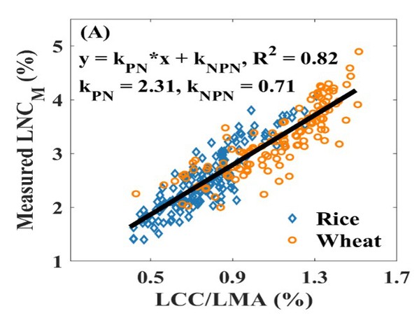
南京农业大学农学院《Remote Sensing of Environment》发表智慧农业团队“Estimating leaf nitrogen content by coupling a nitrogen allocation model with canopy reflectance”(图)
智慧农业 光谱监测 植物光合
font style='font-size:12px;'>
2023/10/28
2022年11月1日,农学院智慧农业团队在国际顶级遥感期刊《Remote Sensing of Environment》发表了题为“Estimating leaf nitrogen content by coupling a nitrogen allocation model with canopy reflectance”的研究论文,报道了他们在冠层尺度氮含量光谱监测普适性模型构建方面的重要进展...
中国地质大学科学技术发展院李显巨,陈伟涛等. 计算机学院, Remote Sensing(2019), Multimodal and Multi-Model Deep Fusion for Fine Classification of Regional Complex Landscape Areas Using ZiYuan-3 Imagery
在地质环境遥感智能解译领域的研究工作取得重要进展
font style='font-size:12px;'>
2021/10/18
近日,中国地质大学计算机学院陈伟涛副教授团队在地质环境遥感智能解译领域的研究工作取得重要进展。相关研究成果发表在国际著名期刊《Remote Sensing》。论文第一作者为李显巨副教授,通讯作者为陈伟涛副教授。
中国地质大学科学技术发展院童伟(硕士研究生),陈伟涛*,王力哲* 等,计算机学院. Journal of Selected Topics in Applied Earth Observations and Remote Sensing(2020). Channel-Attention-Based DenseNet Network for Remote Sensing Image Scene Classification
智能;获取;遥感敏感特征;遥感;场景分类;关键技术;瓶颈
font style='font-size:12px;'>
2021/10/15
近日,对地观测领域国际重要期刊《Journal of Selected Topics in Applied Earth Observations and Remote Sensing》刊发了中国地质大学计算机学院遥感智能解译团队的研究成果――“Channel-Attention-Based DenseNet Network for Remote Sensing Image Scene Classi...
LANDSCAPE VULNERABILITY ASSESSMENT USING REMOTE SENSING AND GIS TOOLS IN THE INDIAN PART OF KAILASH SACRED LANDSCAPE
KSL AHP Vulnerability Fire Flood Landslide
font style='font-size:12px;'>
2019/2/27
The Indian part of Kailash Sacred Landscape (KSL) is prone to flash floods, landslides and forest fires leading to various environmental and socio-economic problems. This study aims to identify areas ...
A COMPARATIVE ANALYSIS OF DROUGHT INDICES ON VEGETATION THROUGH REMOTE SENSING FOR LATUR REGION OF INDIA
Agriculture drought Vegetation Condition Index (VCI) Temperature Condition Index (TCI) Vegetation Health Index (VHI) drought assessment
font style='font-size:12px;'>
2019/2/27
Drought intensifies stress on the water resource which is already in a critical condition due to rapid urbanization and population growth thus, affecting people, economy, and environment. The drought ...
ESTIMATION OF INSTANTANEOUS EVAPOTRANSPIRATION USING REMOTE SENSING BASED ENERGY BALANCE TECHNIQUE OVER PARTS OF NORTH INDIA
Evapotranspiration Energy Balance Approach Remote Sensing Sensible heat flux
font style='font-size:12px;'>
2019/2/27
Evapotranspiration (ET) is an essential element of the hydrological cycle and plays a significant role in regional and global climate through the hydrological circulation. Estimation and monitoring of...
ASSESSING THE IMPACT OF CANAL NETWORK ON SURFACE WATERLOGGING USING REMOTE SENSING DATASETS IN ROHTAK DISTRICT, HARYANA
Waterlogging Canals Remote Sensing GIS Rohtak
font style='font-size:12px;'>
2019/2/27
Remote Sensing is a very reliable and expeditious technique for assessment and mapping of surface waterlogged areas. In this study band ratio based NDWI index (Normalized Difference Water Index) was u...
SPECTRAL-SPATIAL CLASSIFICATION OF HYPERSPECTRAL REMOTE SENSING IMAGES USING VARIATIONAL AUTOENCODER AND CONVOLUTION NEURAL NETWORK
Hyperspectral classification feature extraction spectral channels deep learning
font style='font-size:12px;'>
2019/2/28
In this paper, we propose a spectral-spatial feature extraction framework based on deep learning (DL) for hyperspectral image (HSI) classification. In this framework, the variational autoencoder (VAE)...
COUPLE GRAPH BASED LABEL PROPAGATION METHOD FOR HYPERSPECTRAL REMOTE SENSING DATA CLASSIFICATION
Graph Label Propagation Semi-Supervised method Classification Hyperspectral Remote Sensing
font style='font-size:12px;'>
2018/5/15
Graph based semi-supervised classification method are widely used for hyperspectral image classification. We present a couple graph based label propagation method, which contains both the adjacency gr...
URBAN SPATIAL ECOLOGICAL PERFORMANCE BASED ON THE DATA OF REMOTE SENSING OF GUYUAN
Urban Spatial Ecological Performance Urban Landuse High-resolution Remote Sensing Data
font style='font-size:12px;'>
2018/5/15
The evolution analysis of urban landuse and spatial ecological performance are necessary and useful to recognizing the stage of urban development and revealing the regularity and connotation of urban ...
GRASSLAND NPP MONITORING BASED ON MULTI-SOURCE REMOTE SENSING DATA FUSION
Multi-source remote sensing Data fusion Net primary productivity Carnegie-Ames-Stanford Approach model
font style='font-size:12px;'>
2018/5/11
Vegetation is an important part of the terrestrial ecosystem. It plays an important role in the energy and material exchange of the ground-atmosphere system and is a key part of the global carbon cycl...
CONTINUOUS CHANGE DETECTION OF URBAN LAKES IN WUHAN, CHINA USING MULTI-TEMPORAL REMOTE SENSING IMAGES
Change Detection Urban Lakes Multi-temporal Remote Sensing Images Modified NDWI Wuhan City
font style='font-size:12px;'>
2018/5/16
Urban lakes are important natural, scenic and pattern attractions of the city, and they are potential development resources as well. However, lots of urban lakes in China have been shrunk significantl...