搜索结果: 1-7 共查到“物理学 Remote Sensing”相关记录7条 . 查询时间(0.109 秒)

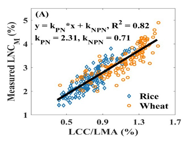
南京农业大学农学院《Remote Sensing of Environment》发表智慧农业团队“Estimating leaf nitrogen content by coupling a nitrogen allocation model with canopy reflectance”(图)
智慧农业 光谱监测 植物光合
font style='font-size:12px;'>
2023/10/28
2022年11月1日,农学院智慧农业团队在国际顶级遥感期刊《Remote Sensing of Environment》发表了题为“Estimating leaf nitrogen content by coupling a nitrogen allocation model with canopy reflectance”的研究论文,报道了他们在冠层尺度氮含量光谱监测普适性模型构建方面的重要进展...
COUPLE GRAPH BASED LABEL PROPAGATION METHOD FOR HYPERSPECTRAL REMOTE SENSING DATA CLASSIFICATION
Graph Label Propagation Semi-Supervised method Classification Hyperspectral Remote Sensing
font style='font-size:12px;'>
2018/5/15
Graph based semi-supervised classification method are widely used for hyperspectral image classification. We present a couple graph based label propagation method, which contains both the adjacency gr...
SEMANTIC SEGMENTATION OF CONVOLUTIONAL NEURAL NETWORK FOR SUPERVISED CLASSIFICATION OF MULTISPECTRAL REMOTE SENSING
Semantic Segmentation Multi Spectral Remote Sensing Convolutional Neural Network U-net multi-scale image
font style='font-size:12px;'>
2018/5/16
Semantic segmentation is a fundamental research in remote sensing image processing. Because of the complex maritime environment, the classification of roads, vegetation, buildings and water from remot...
SPIE Remote Sensing 2016
NEW - Remote Sensing Technologies Lidar Technologies
font style='font-size:12px;'>
2016/7/22
Plan to attend SPIE Remote Sensing 2016 - the event that offers engineers, scientists, programme managers and policy makers access to the latest developments in earth observing systems, technologies a...
PREDICTION OF BIODIVERSITY - CORRELATION OF REMOTE SENSING DATA WITH LICHEN FIELD SAMPLES
Orthoimage Modelling Land Cover Prediction Correlation High resolution Segmentation Environment
font style='font-size:12px;'>
2015/7/29
The objective of the present study was to develop a model to predict lichen species richness for six test sites in the Swiss Pre-Alps
following a gradient of land use intensity combining airborne re...
GROUND SPECTROMETRY DATA - A BASIS OF REMOTE SENSING DATA VERIFICATION
Ground spectrometry Remote sensing Vegetation Identification Hemp
font style='font-size:12px;'>
2015/7/29
In the paper the optical reflection spectra of native hemp and contiguous plants are presented. The spectra were obtained by ground
spectrometry methods in field condition. The analysis of spectra s...
Remote Sensing and Synchronous Land Surface Measurements of Soil Moisture and Soil Temperature in the Field
Remote Sensing Synchronous Land Surface Measurements Soil Temperature
font style='font-size:12px;'>
2010/4/19
The paper presents the results of remote sensing and synchronous land surface measurements for estimation of soil (surface and profile) water content and soil temperature for different soil types in B...

