搜索结果: 1-15 共查到“工学 Information Fusion”相关记录17条 . 查询时间(0.062 秒)

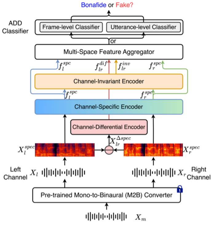
内蒙古大学计算机学院刘瑞研究员团队最新研究论文在人工智能领域国际权威期刊Information Fusion发表(图)
刘瑞 人工智能 Information Fusion 音频
font style='font-size:12px;'>
2024/8/9
Information fusion in tree classifiers
Hierarchial classification Information Fusion Neural Networks
font style='font-size:12px;'>
2016/5/20
Three methods of fusing information from maximum liklihood and neural network methods for multispectral
data classification are discussed in this paper. The purpose of the fusion is to ...
A REMOTE SENSING IMAGE SEGMENTATION METHOD BASED ON SPECTRAL AND STRUCTURE INFORMATION FUSION
Segmentation Mean Shift Information Fusion
font style='font-size:12px;'>
2015/12/31
The focus of this paper is on the segmentation algorithm for the high resolution multispectral imagery to get regions which are roughly corresponding to land cover types. We propose the combination of...
VEGETATION COVER CHANGE MONITORING AND ANALYZING IN HUANGHE-HUAIHE-HAIHE ZONE BASED ON MULTI-SOURCE INFORMATION FUSION
Holdridge Unsupervised Classification Yellow River-Huai River-Hai River Area Multi-source Information Changing of Vegetation Coverage
font style='font-size:12px;'>
2015/12/31
Vegetation, as the comprehensive reflection of climate and other environmental elements, is closely related with climate changes.The article, on the basis of Holdridge life zone index method and the u...
Object Information Automatic Extraction from High Resolution Stereo Pairs by Dense Image Matching and Information Fusion
Digital Surface Model High Resolution Stereo Image Pairs Feature Matching
font style='font-size:12px;'>
2015/12/18
With the advent of digital sensor, the requirement for new Photogrammetric software is urgent to quick object information extraction from high-resolution stereo pairs. This paper describes an effectiv...
DETECTION OF HOTSPOTS IN NOAA/AVHRR IMAGES USING PRINCIPAL COMPONENT ANALYSIS AND INFORMATION FUSION TECHNIQUE
Hotspots NOAA/AVHRR Satellite Imaging
font style='font-size:12px;'>
2015/8/28
India accounts for the world’s greatest concentration of coal fires which cause several devastating environmental effects. Only Jharia
Coal Field (JCF) in Jharkhand (India) contains nearly half of su...
Web-based framework for ps-insar data interpretation assisted by geo-spatial information fusion
(PS)-InSAR Interpretation Information fusion
font style='font-size:12px;'>
2015/8/21
This study investigates the options of information mining to enhance interpretation of PS-InSAR results of land subsidence analysis.
Persistent Scatterer (PS) Interferometric Synthetic Aperture Radar...
ORDERING CRITERIA AND INFORMATION FUSION IN 3D LASER SURVEYING OF SMALL URBAN SPACES
Laser Scanner Surveying Architecture Data Processing Virtual Reality
font style='font-size:12px;'>
2015/8/7
The introduction of laser-based photogrammetry in the surveying of Cultural Heritage provides an increasing volume of data, which
requires multi-resolution approaches for analyzing and displaying th...
OBJECT EXTRACTION AND RECOGNITION FROM LIDAR DATA BASED ON FUZZY REASONING AND INFORMATION FUSION TECHNIQUES
3D Objects Extraction Recognition Fuzzy logic LIDAR Region growing
font style='font-size:12px;'>
2015/7/30
Three dimensional object extraction and recognition (OER) from LIDAR data has been an area of major interest in photogrammetry
for quite a long time. However, most of the existing methods for automa...
3D-INFORMATION FUSION FROM VERY HIGH RESOLUTION SATELLITE SENSORS
Stereo satellites DSM 3D-objects
font style='font-size:12px;'>
2015/5/7
In this paper we show the pre-processing and potential for environmental applications of very high resolution (VHR) satellite stereo imagery like these from WorldView-2 or Pleiades with ground sampli...
THE DESIGN AND IMPLEMENTATION OF A NOVELL OBJECT RECOGNITION METHOD BASED ON INFORMATION FUSION AND ARTIFICIAL INTELLIGENT I CONCEPT
THE DESIGN AND IMPLEMENTATION A NOVELL OBJECT RECOGNITION METHOD INFORMATION FUSION ARTIFICIAL INTELLIGENT
font style='font-size:12px;'>
2015/3/16
THE DESIGN AND IMPLEMENTATION OF A NOVELL OBJECT RECOGNITION METHOD BASED ON INFORMATION FUSION AND ARTIFICIAL INTELLIGENT I CONCEPT.
POST-CLASSIFICATION APPROACH BASED ON GEOSTATISTICS TO REMOTE SENSING IMAGES : SPECTRAL AND SPATIAL INFORMATION FUSION
Classification Information Fusion Spectral Spatial Geostatistics Kriging
font style='font-size:12px;'>
2014/4/29
Classification of remote sensing imagery provides an inexpensive yet efficient approach to land cover mapping. In supervised image classification, training samples are collected through certain sampli...
Monitoring Computer Numerical Control Machining Progress Based on Information Fusion
machining progress information fusion machining path CNC machining
font style='font-size:12px;'>
2011/8/4
To cope with the market demand dynamically, enterprise needs to obtain the production status of work in process real-timely, but the information of machining progress has feature of uncertainty and ca...
基于分层传感器信息融合的智能车辆导航(Navigation Study for Intelligent Vehicle Based on Layered Sensor Information Fusion)
智能车辆 导航控制 分层传感器融合
font style='font-size:12px;'>
2009/11/24
针对智能车辆导航中传感器信息的不确定性,结合BP神经网络和模糊神经网络分别对传感器信息进行了数据层与决策层的两层融合。采用BP神经网络对多超声波传感器信息进行数据层融合,以减少超声波测距传感器信息的不确定性,提高对障碍物距离探测的准确率;采用模糊神经网络融合障碍物距离信息和车体与标志线间偏差信息,实现智能车辆的导航决策控制,使之更适合系统的跟踪避障要求。该方法使智能车辆在跟踪与避障中具有较好的灵活...
基于机器视觉和信息融合的邻接苹果分割算法(Separating Adjoined Apples Based on Machine Vision and Information Fusion)
苹果 机器视觉 信息融合
font style='font-size:12px;'>
2009/11/24
提出了利用亮度和颜色的信息融合来分割邻接苹果的方法。首先使用Lab模型对苹果图像进行分割,然后计算分割后每个区域的面积,并判断其是否为邻接苹果区域。接着在邻接区域内计算亮度信息,利用亮度产生的亮斑对邻接苹果进行分割。这样,在邻接区域以外的部分,亮度信息产生的噪声被Lab模型的信息屏蔽,而邻接区域以内的部分,具有惟一性的亮度信息可以较好分割经Lab模型处理后的邻接苹果。实验表明,此算法对邻接苹果识别...


