
ЫбЫїНсЙћ: 1-15 ЙВВщЕНЁАЙЄбЇ trackЁБЯрЙиМЧТМ40Ьѕ . ВщбЏЪБМф(0.136 Уы)
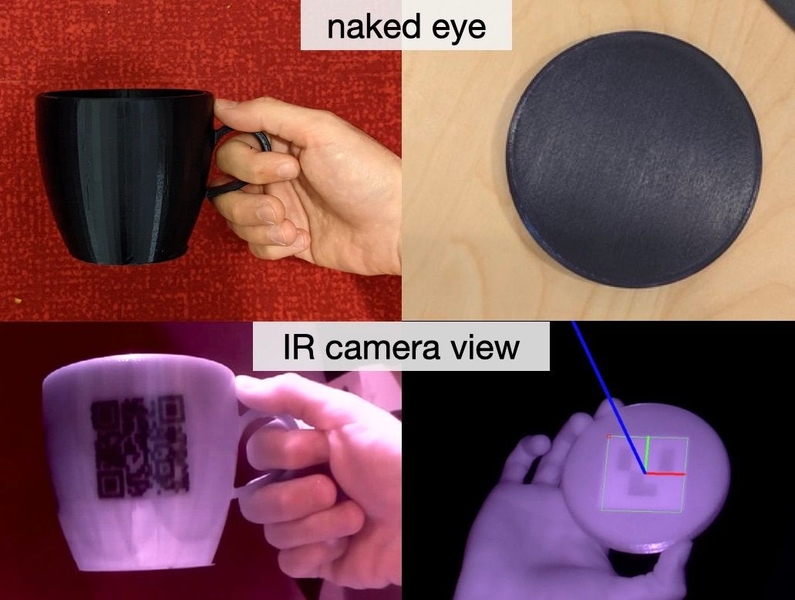
Invisible machine-readable labels that identify and track objectsЃЈЭМЃЉ
ВЛПЩМћ ЛњЦїПЩЖСБъЧЉ 3DДђгЁБъЧЉ Ъ§ОнДцДЂЗжРр
font style='font-size:12px;'>
2023/6/7
If you download music online, you can get accompanying information embedded into the digital file that might tell you the name of the song, its genre, the featured artists on a given track, the compos...
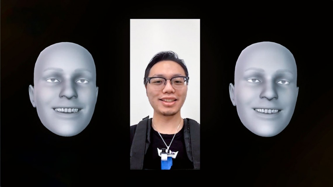
Smart necklace could track your detailed facial expressionsЃЈЭМЃЉ
жЧФмЯюСД Ињзй УцВПБэЧщ
font style='font-size:12px;'>
2023/5/19
Human facial movements convey emotions, and help us communicate nonverbally and perform physical activities, such as eating and drinking.
ACADEMIC TRACK OF FOSS4G 2018 ЈC LEAVING NO-ONE BEHIND
FOSS4G Dar es Salaam Academic Track Preface
font style='font-size:12px;'>
2018/11/8
Namangaya, A. H. and Brovelli, M. A.: PREFACE: ACADEMIC TRACK OF FOSS4G 2018 ЈC LEAVING NO-ONE BEHIND, Int. Arch. Photogramm. Remote Sens. Spatial Inf. Sci., XLII-4/W8, 1-2, https://doi.org/10.5194/isp...

Computer scientists use music to covertly track body movements,activityЃЈЭМЃЉ
Computer scientists music covertly track body movements activity
font style='font-size:12px;'>
2017/9/5
As smartphones, tablets, smart TVs and other smart devices become more prevalent in our lives, computer scientists have raised concerns that these network-enabled devices, if not properly secured, cou...
IEEE2017ЙњМЪЙЄвЕДѓЪ§ОнбаЬжЛсЃЈIEEE International Workshop on big data industrial trackЃЉ
ЙњМЪЙЄвЕДѓЪ§Он баЬжЛс
font style='font-size:12px;'>
2017/3/27
The objective of the Industry Track program is to establish an efficient dialogue between big data practitioners and researchers concerning the challenges, solutions, lessons learned on implementing b...
GMES FAST TRACK LAND SERVICE 2006-2008 ORTHORECTIFICATION OF SPOT 4/5 AND IRS-P6 LISS III DATA
Spaceborne Remote Sensing Orthorectification Space Photogrammetry IRS SPOT Land Cover GMES
font style='font-size:12px;'>
2016/1/3
The GMES (Global Monitoring for Environment and Security) Fast Track Land monitoring Service (FTLS) is a service to provide on a regular basis land cover and land use change datasets, which can be use...
Across-Track Imaging Accuracy Analysis and Research of High Resolution Satellite Imagery in Metropolitan Area
Accuracy Improvement Ground Control Points Rational Function Model
font style='font-size:12px;'>
2015/12/18
High Resolution Satellite Imagery (HRSI) is now being used more and more in city development. The geometric correction of HRSI is the basis of all the image process work for other application such as ...
IQPC 2015 TRACK:WATER DETECTION AND CLASSIFICATION ON MULTISOURCE REMOTE SENSING AND TERRAIN DATA
IQmulus Processing Contest Remote Sensing Water detection and classification Multi-source remote sensing data processing Resource optimization R programming
font style='font-size:12px;'>
2015/9/21
Since 2013, the EU FP7 research project ЁАIQmulusЁБ encourages the participation of the whole scientific community as well as specific user groups in the IQmulus Processing Contest (IQPC). This year, IQ...
IQPC 2015 TRACK:TREE SEPARATION AND CLASSIFICATION IN MOBILE MAPPING LIDAR DATA
Mobile mapping systems Lidar Tree separation Classification
font style='font-size:12px;'>
2015/9/21
The European FP7 project IQmulus yearly organizes several processing contests, where submissions are requested for novel algorithms for point cloud and other big geodata processing. This paper describ...
IQPC 2015 Track: EVALUATION OF AUTOMATICALLY GENERATED 2D FOOTPRINTS FROM URBAN LIDAR DATA
LiDAR data Aerial Laser Scanning Building Detection Road Detection Evaluation Strategy
font style='font-size:12px;'>
2015/9/21
Over the last decade, several automatic approaches have been proposed to extract and reconstruct 2D building footprints and 2D road profiles from ALS data, satellite images, and/or aerial imagery. Sin...
AUTOMATIC PRODUCTION OF A EUROPEAN ORTHOIMAGE COVERAGE WITHIN THE GMES LAND FAST TRACK SERVICE USING SPOT 4/5 AND IRS-P6 LISS III DATA
GMES IMAGE2006 CLC2006 orthoimages matching SPOT 4 SPOT 5 IRS-P6
font style='font-size:12px;'>
2015/9/17
Since the mid 1980s an European Land Cover dataset has been regularly produced for land cover changes, land cover map (CORINE), high resolution forest layer and built-up areas including soil sealing. ...
SAHRIS: using the South African Heritage Register to report, track and monitor heritage crime
SAHRIS heritage crime objects
font style='font-size:12px;'>
2015/9/11
South Africa has experienced a recent increase in thefts of heritage objects from museums and galleries around the country. While the
exact number of incidences is not known, the increase in thefts i...
Inspired by art,lightweight solar cells track the sun
Inspired by art lightweight solar cells track the sun
font style='font-size:12px;'>
2015/9/18
Solar cells capture up to 40 percent more energy when they can track the sun across the sky, but conventional, motorized trackers are too heavy and bulky for pitched rooftops and vehicle surfaces.Now,...
an improved model for along track stereo sensors using rigorous orbit mechanics and navigation data
along track sensor model orbit determination Kepler motion navigation data
font style='font-size:12px;'>
2015/9/1
In this paper a major improvement of the generic rigorous sensor model for along track stereo optical satellite sensors which has been developed at UCL over the last three years is introduced, in deta...
ANALYSIS OF DEMs FROM ACROSS TRACK STEREO PAIRS FOR A PART OF KACHCHH REGION
IRS PAN Stereo data Kachchh region image matching
font style='font-size:12px;'>
2015/8/28
Orbital stereo data is acquired by covering same area from two exposure stations in space with oblique viewing capability. It is
used for generating digital elevation models (DEM) and three dimension...
жаЙњбаОПЩњНЬг§ХХааАё-Ьѕ
- е§дкМгди...
жаЙњбЇЪѕЦкПЏХХааАё-Ьѕ
- е§дкМгди...
ЪРНчДѓбЇПЦбаЛњЙЙХХааАё-Ьѕ
- е§дкМгди...
жаЙњДѓбЇХХааАё-Ьѕ
- е§дкМгди...
ШЫЁЁЮя-ЦЊ
- е§дкМгди...
ПЮЁЁМў-ЦЊ
- е§дкМгди...
ЪгЬ§зЪСЯ-ЦЊ
- е§дкМгди...
баеазЪСЯ -ЦЊ
- е§дкМгди...
жЊЪЖвЊЮХ-ЦЊ
- е§дкМгди...
ЙњМЪЖЏЬЌ-ЦЊ
- е§дкМгди...
ЛсвщжааФ-ЦЊ
- е§дкМгди...
бЇЪѕжИФЯ-ЦЊ
- е§дкМгди...
бЇЪѕеОЕу-ЦЊ
- е§дкМгди...